Capitol Reef sits in the heart of Utah’s five national parks known as the “Mighty 5,” making it the perfect stop for travelers road-tripping between Zion, Bryce Canyon, Arches, and Canyonlands. Many visitors trying to hit all five parks are on a tight schedule with much ground to cover, and often only have a single day to spend in each park. Fortunately, Capitol Reef’s layout makes that easy, and you can experience classic viewpoints, historic sites, and rewarding short hikes without venturing deep into the backcountry.
This guide outlines how to make the most of one day in Capitol Reef, from must-see stops and scenic viewpoints, to recommended hikes and helpful planning tips.
Capitol Reef National Park at a Glance
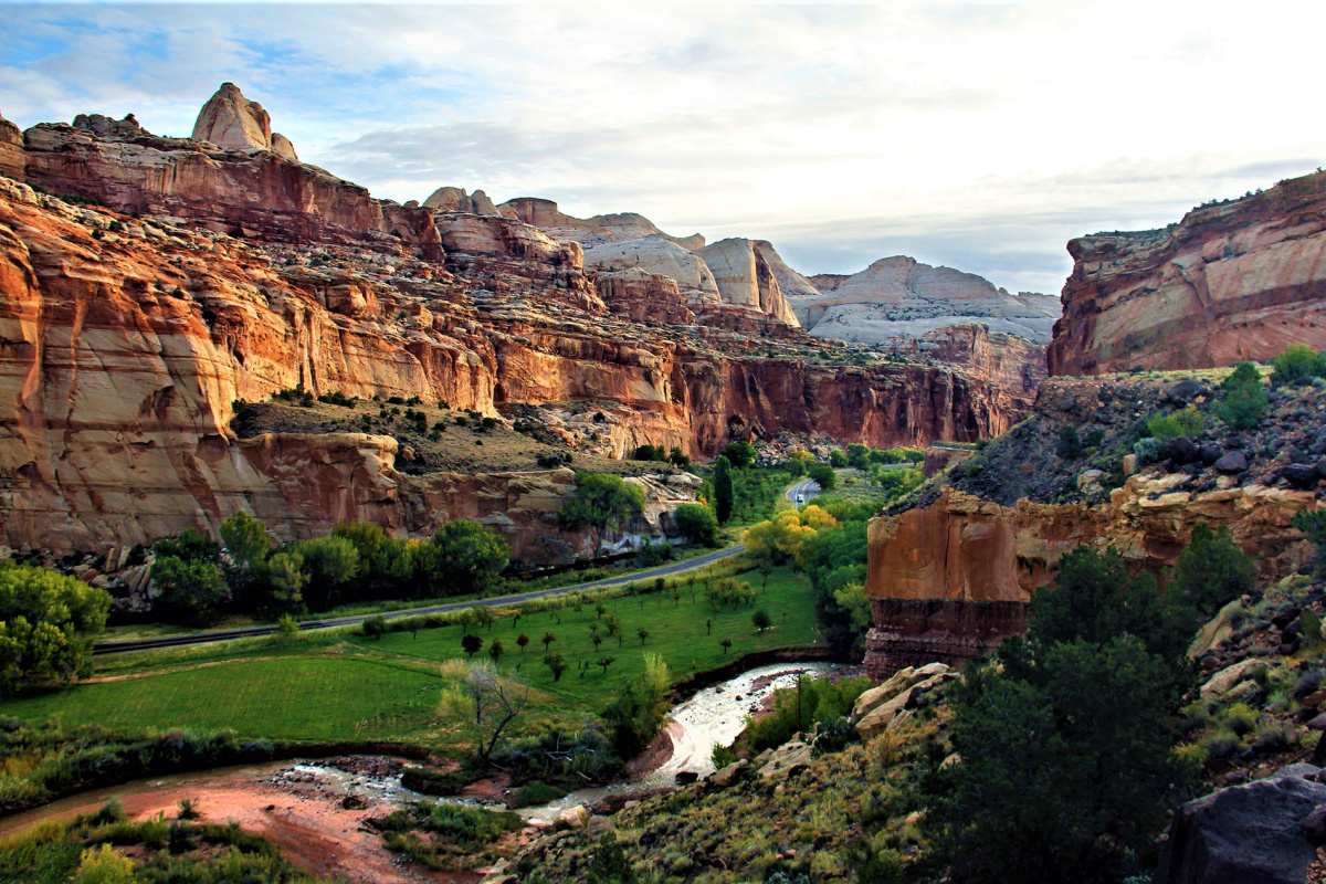
Capitol Reef National Park covers 378 square miles with a landscape of towering domes, narrow canyons, historic orchards, and the Waterpocket Fold – a 100-mile-long geological uplift at the heart of the park. Most of the park is considered back country, meaning off the beaten trail and away from paved roads and services. To truly experience the depth of Capitol Reef requires a multi-day trip to explore areas away from the busier sites near highway 24. For those with limited time or experience, the best way to see the back country is to go with a commercial outfitter.
For those who don’t have time or resources to venture into the wilderness of Capitol Reef, the main routes through the park still offer access to much of the park’s iconic scenery. If you only have a day, here are a few suggestions to help you plan your day and get the most out of the stops along the main routes of the park.
The Park’s Two Main Roads
There are only two paved roads in Capitol Reef:
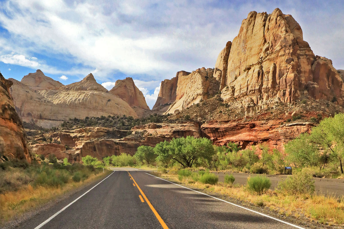
State Route 24, is the main road through the park, running east-west. Many viewpoints and trailheads are accessible directly from this highway.
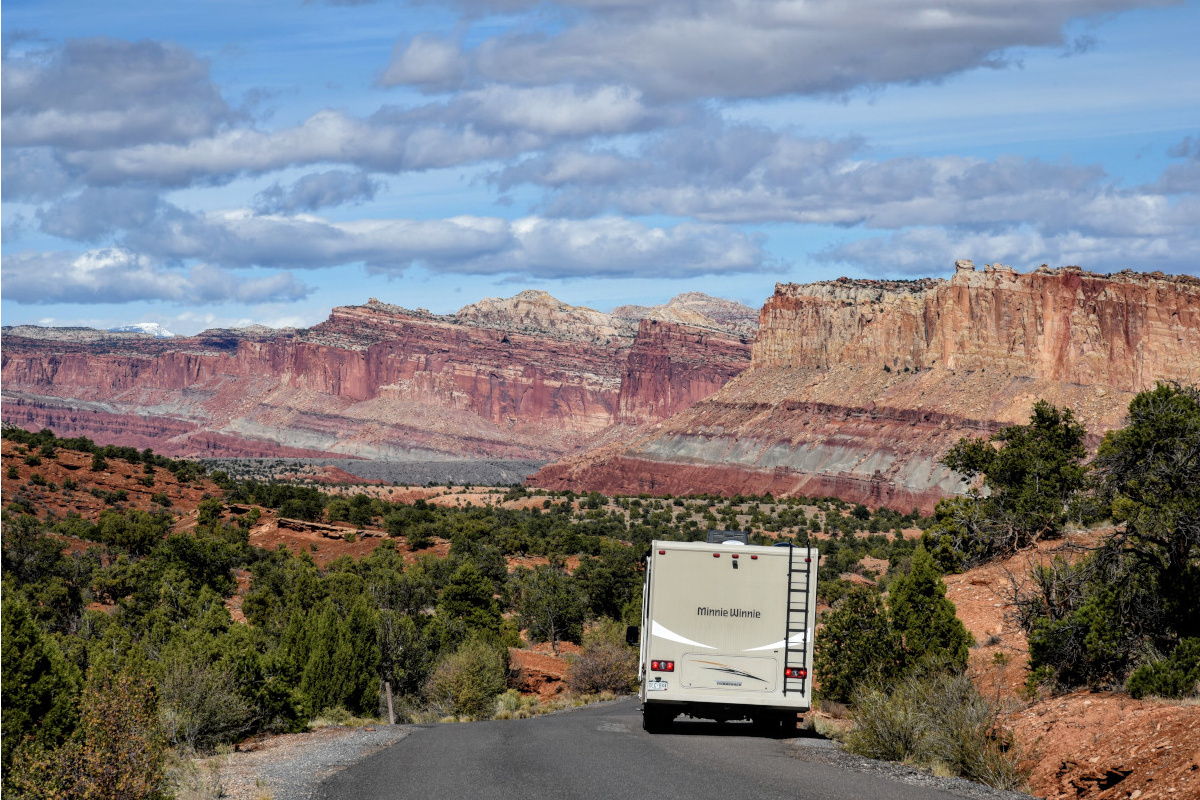
The Scenic Drive begins in Fruita and heads south toward Grand Wash and Capitol Gorge. It is an almost 8 mile paved road filled with dramatic red-rock views and access to several popular hikes. A park entrance fee is required for this portion of the drive.
These scenic roads make the perfect route for your day trip in the park, with easy stops along the way to make the most of your time in the park.
Highway 24 Sites and Hikes (East to West)
Use this easy itinerary for your stops throughout the day if you enter the park from Hanksville and follow this order of stop from East to West.
Behunin Cabin
If you enjoy history, you’ll enjoy visiting this small cabin built in 1883 by one of Capitol Reef’s early settlers. The quick roadside stop offers a glimpse into pioneer life in this harsh, remote desert.
Grand Wash Trailhead (Optional Hike)
Located 1.5 miles west of the Behunin Cabin, this hike is one of the best “bang for your buck” experiences in the park. You’ll walk through a wash among beautiful towering canyon walls. You can walk the full length one-way of approximately three miles, or go just a short distance in the wash and turn around.
Distance: Up to 6 miles round trip (go as far as you want)
Navajo Dome & Capitol Dome Viewpoint
Located about 2 miles from Grand Wash, you’ll find a designated pull-off with excellent views of the park’s signature white domes. This is a great spot for photos and to appreciate the park’s unique geology.
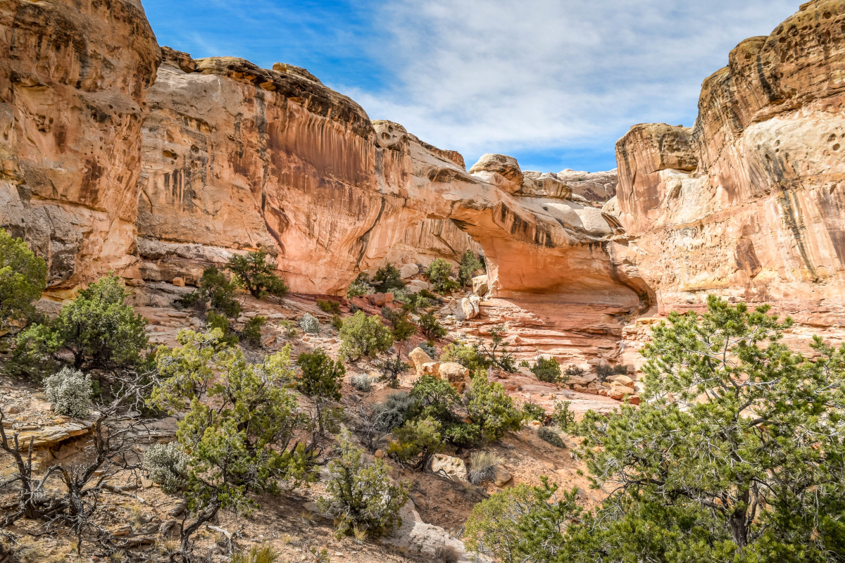
One of the most popular hikes in Capitol Reef, the trail climbs steadily to a natural sandstone bridge hidden from the road. This is a great family-friendly hike. Because this is a very popular destination, parking fills early and overflow parking lines the highway.
Distance: 2 miles round trip
Difficulty: Moderate
Historic Fruita Area: Orchards, Petroglyphs & Schoolhouse
As you travel west from Hickman Bridge on Highway 24, you’ll enter the historic Fruita district, which includes:
Fremont Petroglyphs
A short boardwalk leads to rock panels with ancient petroglyphs carved by the Fremont people over 1,000 years ago. A viewing scope helps you spot the figures high on the cliff.
Fruita Orchards & Wildlife Viewing
The lush orchard area marks the heart of historic Fruita. Depending on the season, visitors can stroll through the orchards or pick fruit when they’re open. This can be a common area to spot wildlife, as mule deer and wild turkeys are often seen wandering the area.
Fruita Schoolhouse
A short distance from the petroglyphs, you’ll find a restored one-room pioneer schoolhouse that operated from 1896 to 1941. This is a quick, worthwhile stop.
Visitor Center & Beginning of the Scenic Drive
Next stop is the visitor center where you can watch a short movie on Capitol Reef, visit the gift shop, pay for entrance fee to drive the Scenic Drive and use the restroom. There is no fee to drive SR-24 through the park but there is a $20 fee for the Scenic Drive beyond the Fruita Campground. Click here for additional details about fees.
The Scenic Drive starts at the visitor center in the historic Fruita district and ends at the beginning of Capitol Gorge where the pavement ends. Before taking off on the drive, we recommend visiting the Gifford pioneer home where you can purchase homemade goods including pies, jams, and bread. This is a very popular stop that’s perfect for having a picnic under the large cottonwood trees.
Grand Wash (Back Side Access)
Two miles from the Fruita Campground is the entrance to the backside of the Grand Wash and is also where the trailhead to Cassidy Arch is located. There is a vault toilet at the trailhead. Be aware that there is limited parking.
Cassidy Arch Trail
This is a steep, scenic hike to a massive sandstone arch named after outlaw Butch Cassidy.
Distance: 3.5 miles round trip
Difficulty: Strenuous
Capitol Gorge
At the end of the Scenic Drive, a short dirt road leads to the Capitol Gorge trailhead. The hike follows a narrow canyon with highlights including:
- The Pioneer Register, where early settlers carved their names
- A short, steep path to The Tanks, natural potholes that can hold water after rain
A vault toilet is available at the parking area. Learn more about Capitol Gorge here.
SR-24 West of the Visitor Center
Panorama Point
From the visitor center on SR-24, drive 2.5 miles west to Panorama Point where 360 degree views of the park are found at the end of a short easy walk up a sandstone slope. If you happen to be in the area at dark, this is a great spot for night sky gazing.
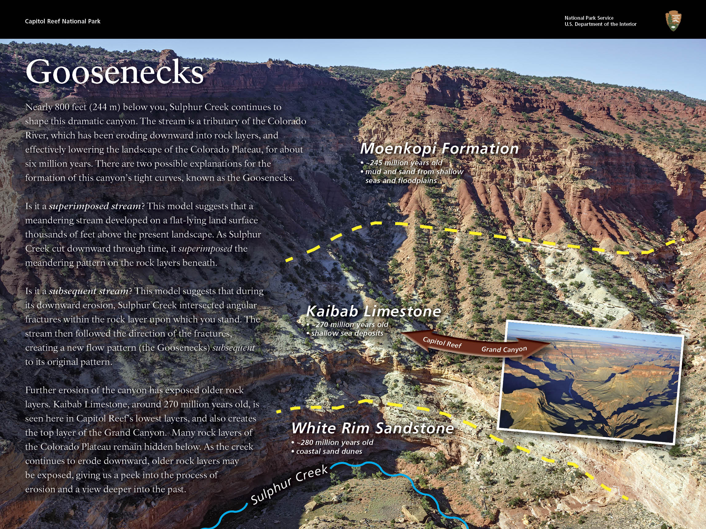
Goosenecks Overlook
When leaving the Panorama Point parking area, before turning down to the highway, you’ll notice an option to turn right on a dirt road. This option takes you .8 miles to Goosenecks Overlook on a graded dirt road. Goosenecks Overlook offers wonderful views at the end of a short hike of the meandering Sulphur Creek 800 ft. below.

Chimney Rock Trail
For those looking for a more adventurous hike, the Chimney Rock Loop Trail rewards you with breathtaking views of Chimney Rock, the western escarpment of the Waterpocket Fold, and Boulder Mountain to the west. With 590 ft. of elevation gain, the tail is rated strenuous, especially for those who are not used to the higher altitude of the Colorado Plateau.
Distance: 3.5 miles
Keep Capitol Reef Country Forever Mighty
What is Forever Mighty? It’s practicing responsible travel while visiting Utah and Capitol Reef Country by following the principles of Tread Lightly and Leave No Trace.
Plan ahead and prepare, travel and camp on durable surfaces, dispose of waste properly, leave what you find, minimize campfire impacts, respect wildlife, be considerate of others, support local business and honor community, history and heritage. Help us keep Utah and Capitol Reef Country’s outdoor recreation areas beautiful, healthy, and accessible.
Have questions about planning your trip? Check out these additional resources:
FAQs
Itineraries & Travel Brochures
Maps
Weather
Or feel free to contact us for more help