

Wander
the Land of GiantsBryce Canyon National Park: The Ultimate Visitor Guide
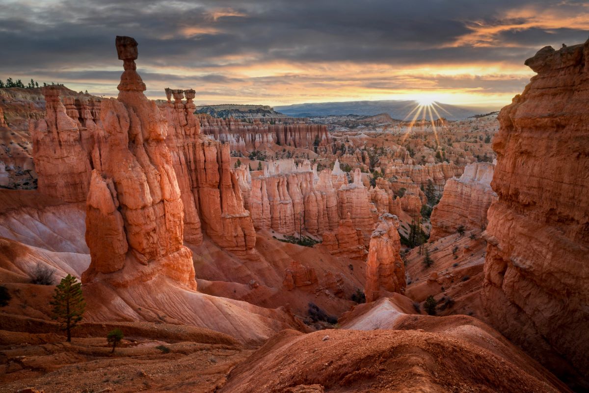
Geology: How the Hoodoos Formed
ANCIENT FORMATIONS:
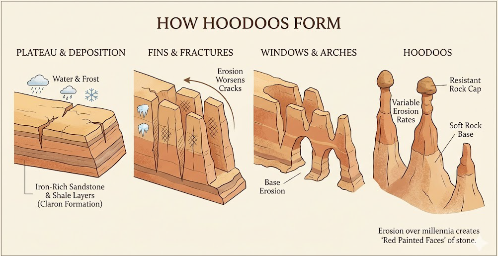
Bryce Canyon amphitheaters have formed, over millennia, as layers of sandstone and shale and iron-rich sandstone and conglomerates were deposited in layers. The last layers called the Claron Formation, are part of the famous Pink Cliffs which form the upper portions of the Grand Staircase.
As streams of water flow from the plateau, they have created thin ridges in the rock contours of the cliffs, known as fins. As these fins erode, they create impressive individual tower formations, at Bryce Canyon, known as hoodoos. These pinnacles have been colored by iron oxide, limonite, and magnesium oxide. With freezing night temperatures in winter, water which has seeped into the rock’s crevices turns to ice. The frozen water then expands and fractures the rock formations creating a cycle of continuing erosion.
Bryce Canyon History
ANCIENT HISTORY:
Over thousands of years, various cultures have inhabited the region surrounding Bryce Canyon National Park. As early as 10,000 years ago, Paleo-Indians hunted large mammals in the region. Then approximately 2,000 years ago, the area became inhabited by the Ancestral Puebloans or the Anasazi who used the area to harvest pine nuts and also to hunt wildlife.
The Bryce Canyon region was next inhabited by the Fremont culture, which lived in the area up until about 1200 AD. Finally, the Paiute people entered the region and stayed until the twentieth century. Hoodoos, a word which is believed to mean “red painted faces” in the Paiute language, were said to be people turned to stone after they had become victims of a displeased coyote.
RECENT HISTORY:
A Spanish explorer passed through this region in 1776 and then Americans began to explore the area in the mid 1800’s. Mormon settlers first surveyed the area in an attempt to discern its usefulness for grazing and other types of habitation. The area was later surveyed by Major John Wesley Powell in 1872. In 1874, the Church of Jesus Christ of Latter-day Saints sent Ebenezer Bryce, the national park’s namesake, to settle the area. Bryce and other settlers soon inhabited the area right below what is known today as Bryce Amphitheater. On one occasion, Ebenezer Bryce lost some of his cattle and he entered one of the nearby Bryce Canyon amphitheaters in search of his animals. His comment upon discovery of this amazing scene, “It’s one hell of a place to lose a cow.”
The area around Bryce National Park first began to gain some notoriety around 1916 when articles of its magnificence were published in several magazines. As interest grew in the Bryce Canyon conservationist Stephen Mather moved to have the area designated as a state park. The Utah governor and state legislature, however, pushed to have the region designated as a national monument, which occurred officially in 1923. Then in February of 1928, the area was designated as Bryce Canyon National Park.
Curated Experiences
Dance Among the Spires
Through a Forest of StoneKnow Before
You Go
HOW TO GET TO BRYCE CANYON
Travel south from the Capitol Reef region on Byway 12. Along the way don’t miss such attractions as; the Burr Trail, Anasazi Indian Village State Park, Calf Creek Falls, Hole in the Rock Road, Devil’s Garden, and Kodachrome Basin State Park.