

Stairway to Grandeur:
Explore the Grand StaircaseGrand Staircase-Escalante National Monument
Curated Experiences
Walk Through a Billion Years
Explore Earth’s Painted PedestalsAccessing the Monument
Grand Staircase-Escalante is divided into three primary regions, each accessed by different gateways. Unlike traditional parks, there is no single entrance; instead, the monument is crisscrossed by several iconic scenic routes.
GATEWAY TOWNS
Escalante & Boulder: Located along Scenic Byway 12, these towns are the primary hubs for the Canyons of the Escalante and the Kaiparowits Plateau.
Kanab: Situated to the southwest, Kanab is the best staging area for exploring the "Grand Staircase" cliffs and the Paria River area.
Big Water: Located on Highway 89 near Lake Powell, this is the gateway to the southern monument and the Great Unconformity
PRIMARY ROADS
Scenic Byway 12: Often called "A Journey Through Time," this paved highway winds through the heart of the monument, offering access to Kiva Coffeehouse and the famous Hole-in-the-Rock Road.
Hole-in-the-Rock Road: A rugged, unpaved 55-mile artery starting near Escalante that leads to the monument's most famous slot canyons and rock formations.
Cottonwood Canyon Road: A scenic (but weather-dependent) dirt road that connects Cannonville to Highway 89, passing through the dramatic Cockscomb formation.
Geology: How the Staircase Formed
THE STORY OF THE STAIRS
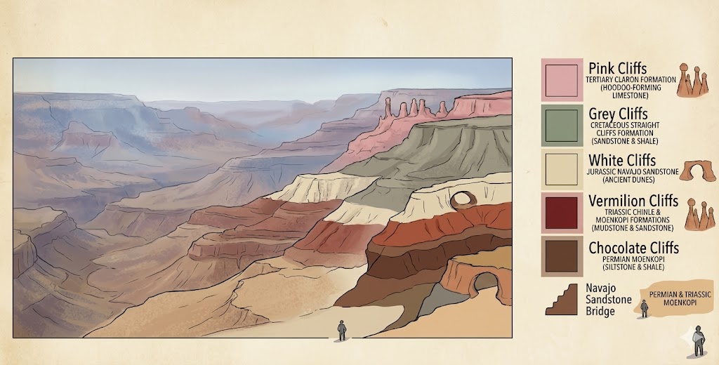
The "Grand Staircase" is a massive sequence of sedimentary rock layers that stretch across Southern Utah. Think of it as a giant, tilted history book where each layer is a "chapter" representing millions of years. Starting from the bottom of the Grand Canyon, these layers step upward toward the north, culminating in the Pink Cliffs of Bryce Canyon.
THE FIVE STEPS OF TIME
The monument is famous for five distinct "steps," each named after the color of the rock cliffs they form:
The Chocolate Cliffs: The oldest and southernmost layer, made of Triassic-aged Moenkopi and Chinle formations.
The Vermilion Cliffs: Deep red sandstone that forms the towering walls of the Paria River canyon.
The White Cliffs: Massive, Navajo Sandstone cliffs that look like frozen sand dunes.
The Gray Cliffs: Rich in shale and coal, these layers are where the most significant dinosaur fossils are found.
The Pink Cliffs: The youngest and highest step, which has eroded into the world-famous hoodoos seen at Bryce Canyon National Park.
Grand Staircase History
ANCIENT HISTORY:
For over 10,000 years, diverse cultures have left their mark on this rugged landscape. The Ancestral Puebloan and Fremont people farmed the river valleys and built intricate granaries in the sandstone alcoves that are still visible today. Modern Tribal Nations, including the Hopi, Navajo (Diné), Paiute, Ute, and Zuni, maintain deep spiritual connections to these lands, considering them a living cultural landscape.
RECENT HISTORY:
Grand Staircase-Escalante was the last place in the contiguous United States to be officially mapped. In 1872, Major John Wesley Powell led an expedition that finally began to chart this "blank spot on the map." Shortly after, Mormon pioneers established the harrowing Hole-in-the-Rock Trail, a 180-mile trek that required them to blast a passage through solid rock to reach the San Juan River.
The area remained a remote ranching frontier until 1996, when President Bill Clinton designated it a National Monument. This was a historic move, as it was the first monument ever managed by the Bureau of Land Management (BLM) with a specific mandate to prioritize scientific research and conservation.
Know Before
You Go
Explore Grand Staircase-Escalante National Monument's canyons, cliffs, & trails. Discover hiking, fossil sites, scenic drives, & backcountry. Plan today!
Never enter a slot canyon like Peek-A-Boo or Spooky if there is any rain in the forecast. Flash floods can travel for miles from distant storms, turning narrow canyons into death traps in seconds. Additionally, the monument's unpaved roads consist of bentonite clay; when wet, they become impassable "grease," even for 4WD vehicles.
If you plan on camping in the backcountry, you must pick up a free permit at one of the Interagency Visitor Centers in Escalante, Kanab, or Big Water.